


| 
|
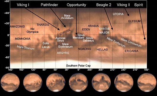
A map of Mars made from images taken in 2003 as part of the creation of a movie of Mars rotating. How this map was made is described here. ©2003
The landing sites of five successful and one failed spacecraft landers (launched as of 2003, when this image was made) are marked on the map along with selected major surface features. Prominent features include Solis Lacus, the "Eye of Mars", and Syrtis Major, an especially dark surface region. The bright spot Nix Olympica marks the location of the largest volcano in the solar system, Olympus Mons. (The region above approximately 71° north appears black because Mars' North Pole was tilted away from Earth during 2003 and wasn't visible for imaging.)
The successful landers were:
- Viking 1 Lander:Landed July 20, 1976, in Chryse Planitia at Mutch Memorial Station, 22.53°N, 47.95°W. Active until November 13, 1982.
- Viking 2 Lander:Landed September 3, 1976, in Utopia Planitia at Soffen Memorial Station, 47.97°N, 225.72°W. Active until April 11, 1980.
- Mars Pathfinder:Landed July 4, 1997, in Ares Vallis at Sagan Memorial Station, 19.33°N, 33.25°W. Active until September 27, 1997.
- Mars Exploration Rover (Spirit):NASA probe launched June 10, 2003, and scheduled for landing January 4 (Jan. 3 in US time), 2004, in Gusev Crater (approximately. 14.59°S 184.70°W).
- Mars Exploration Rover (Opportunity):NASA probe launched July 7, 2003, and scheduled for landing January 25, 2004, in Meridiani Planum (approximately -1.98° N 5.94°W).
The announced location of the other planned (but failed) landing site was:
- Beagle 2:ESA/British Mars Express probe launched June 2, 2003, with landing scheduled December 25 (Dec. 24 in US time) in Isidis Planitia at 11.6°N 269.5°W
| |||||||||||||||||
|
Astrophotography Books – Astronomy Books |